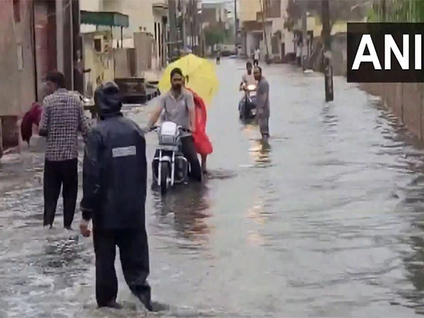
Karnal (Haryana) [India], September 3 (ANI): Amid the continuous rainfall in Haryana, severe waterlogging was seen in the residential areas of Ambala. Parts of Karnal city also witnessed light rainfall on Wednesday morning.
According to the India Meteorological Department (IMD), Ambala’s forecast for today says, “Generally cloudy sky with a few spells of rain or thundershowers”, “Partly cloudy sky with one or two spells of rain or thundershowers” from September 4-6, “Partly cloudy sky with possibility of rain or Thunderstorm” for September 7 and “Generally cloudy sky with possibility of rain or Thunderstorm” for September 8.
According to the IMD, Karnal’s forecast for today and tomorrow is “Generally cloudy sky with a few spells of rain or thundershowers”. The forecast further says, “Partly cloudy sky with one or two spells of rain or thundershowers” for September 5 and 6, “Partly cloudy sky with possibility of rain or Thunderstorm” for September 7, and “Generally cloudy sky with possibility of rain or Thunderstorm” for September 8.”
Meanwhile, the India Meteorological Department (IMD) has issued red alert warnings for several districts across Jammu & Kashmir, Ladakh, Himachal Pradesh, northern Punjab, northern Haryana, eastern Rajasthan, southwest Uttar Pradesh, northwest & eastern Madhya Pradesh, and Odisha.
The updated nowcast suggests moderate to intense spells of rain in these regions over the next three hours, posing risks of flash floods, landslides, and waterlogging.
According to IMD, districts under red alert in Jammu & Kashmir include Poonch, Mirpur, Rajouri, Reasi, Jammu, Ramban, Udhampur, Samba, Kathua, Doda, and Kishtwar. In Punjab, Kapurthala, Jalandhar, Nawashahr, Rupnagar, Moga, Ludhiana, Barnala, and Sangrur are under red alert; while in Himachal Pradesh, Mandi, Una, Bilaspur, Sirmaur, and Solan are under similar warnings. Haryana’s Yamuna Nagar, Ambala, Kurukshetra, Panchkula, and SAS Nagar are also under the same warning.
Meanwhile, today morning, the water level of the Yamuna River in Delhi crossed the danger level mark. The warning mark for the city is 204.5 metres, while the danger mark is 205.33 metres. Evacuation of people starts at 206 metres.
As a preventive measure amid the anticipation of the possible flood situation, people residing in the low-lying areas nearby have been shifted to relief camps set up near Mayur Vihar Phase-1. (ANI)
Disclaimer: This story is auto-generated from a syndicated feed of ANI; only the image & headline may have been reworked by News Services Division of World News Network Inc Ltd and Palghar News and Pune News and World News

HINDI, MARATHI, GUJARATI, TAMIL, TELUGU, BENGALI, KANNADA, ORIYA, PUNJABI, URDU, MALAYALAM
For more details and packages